
Robotto
Wildfires are a deadly symptom of global warming. They are cause of a great environmental impact, destroying wildlife and flora. In the bushfires of Australia in the winter of 2019/2020, 12 million ha. were burned away and 100 Billion AUS were spend in damages and firefighter efforts. Due to the rapid evolution and speed of wildfires, firefighters are looking for technologies to provide data on how best to combat the wildfires. Current wildfire data gethering, using satellites, planes, helicopters, and manually controlled drones, is time consuming, rescource heavy, and provides inaccurate data. Moreover, reconnaissance operations from helicopters and planes are very dangerous, and stands for 24% of deaths in wildfire operations.
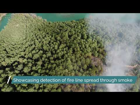
We have developed an autonomous wildfire recognition and analytics drone, AWRA. This will provide the user with an out-of-box method for fast and accurate data gathering and monitoring of the wildfire. The user will utilize a tablet to mark an area for the drone to search in, and will receive real-time feedback regarding the location, size, intensity, and direction of the wildfire. Giving the firefighters back the initiative, and allow them for faster smarter descision making, ultimately extinquishing the wildfires faster. But our product can also solve many other real-world problems, such as Oil Spill Reconnaissance, Search and Rescue, First Responder, and Infrastructure Inspection.
| Location | Denmark |
| Website | robotto.dk |
| Founded | 2019 |
| Employees | 11-50 |
| Industries | IT & Software, SaaS, Science & Engineering, Robotics |
| Business model | B2B, B2G |
| Funding state | Pre-seed |


Working at
Robotto
This job comes with several perks and benefits

“Failure is an option here. If things are not failing, you are not innovating.”
Elon Musk,
CEO
Key numbers
9
Nationalities
11
Employees
€490k
Money raised
SDGs


